
Key Outcomes of the Reimagined Network Scenarios
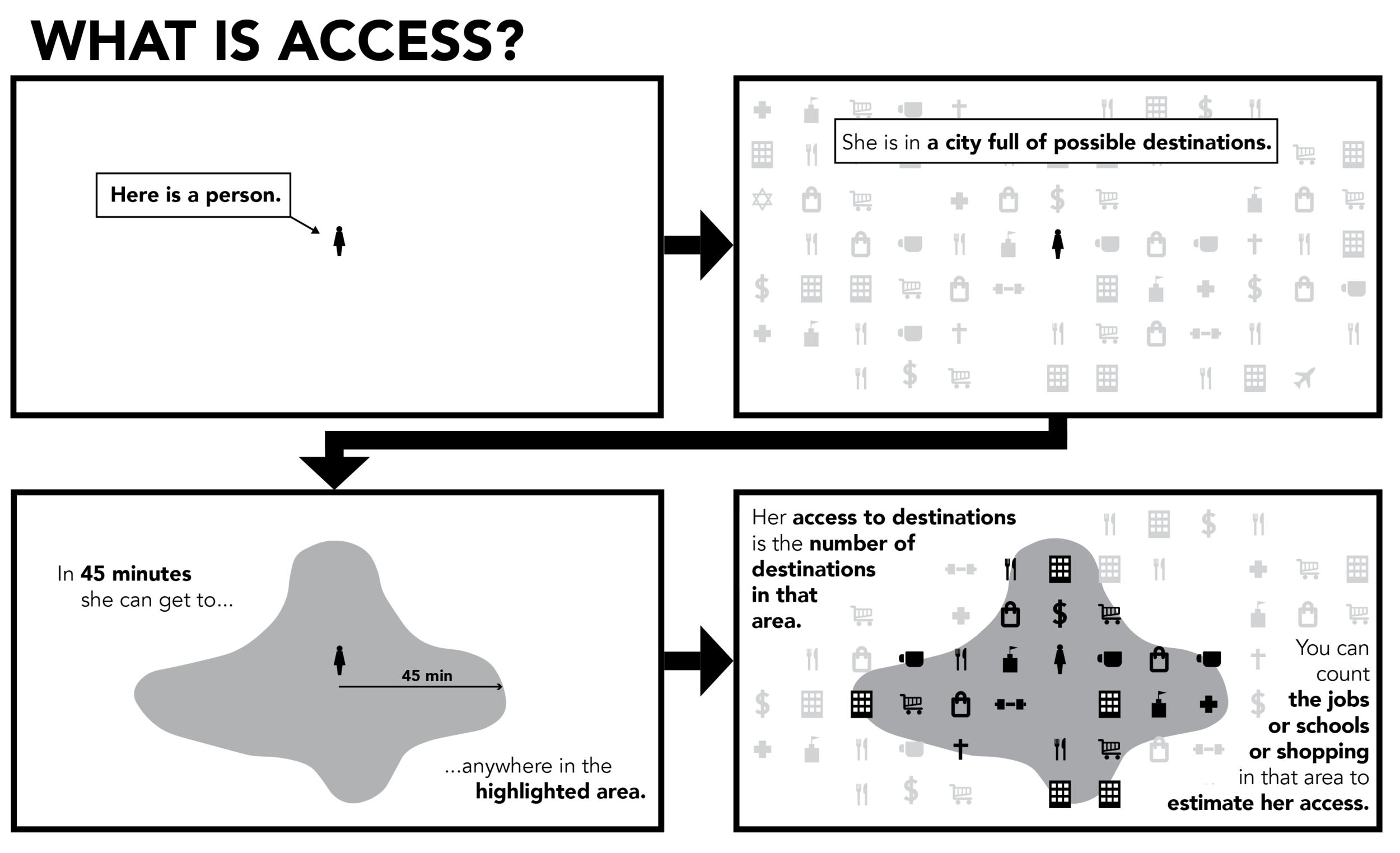
Reimagine METRO is a new plan to provide more useful transit service to residents and visitors of Summit County. This page explains the measures we use to understand how the transit network’s usefulness to residents could change with the Reimagined Network and Growth Scenarios.
One of the most important questions to ask when evaluating changes to the transit network is "Does it make transit more convenient for people to get where they need to go in a relatively short travel time?"
With access analysis, we can measure the number of jobs reachable from different places in 30, 45 or 60 minutes with either the Draft Reimagined Network or the Existing Network.
Measuring job access tells us more than where people could go to work. Other common destinations are also places of employment, such as universities, shopping centers, or hospitals.
The Reimagined Network Expands Access
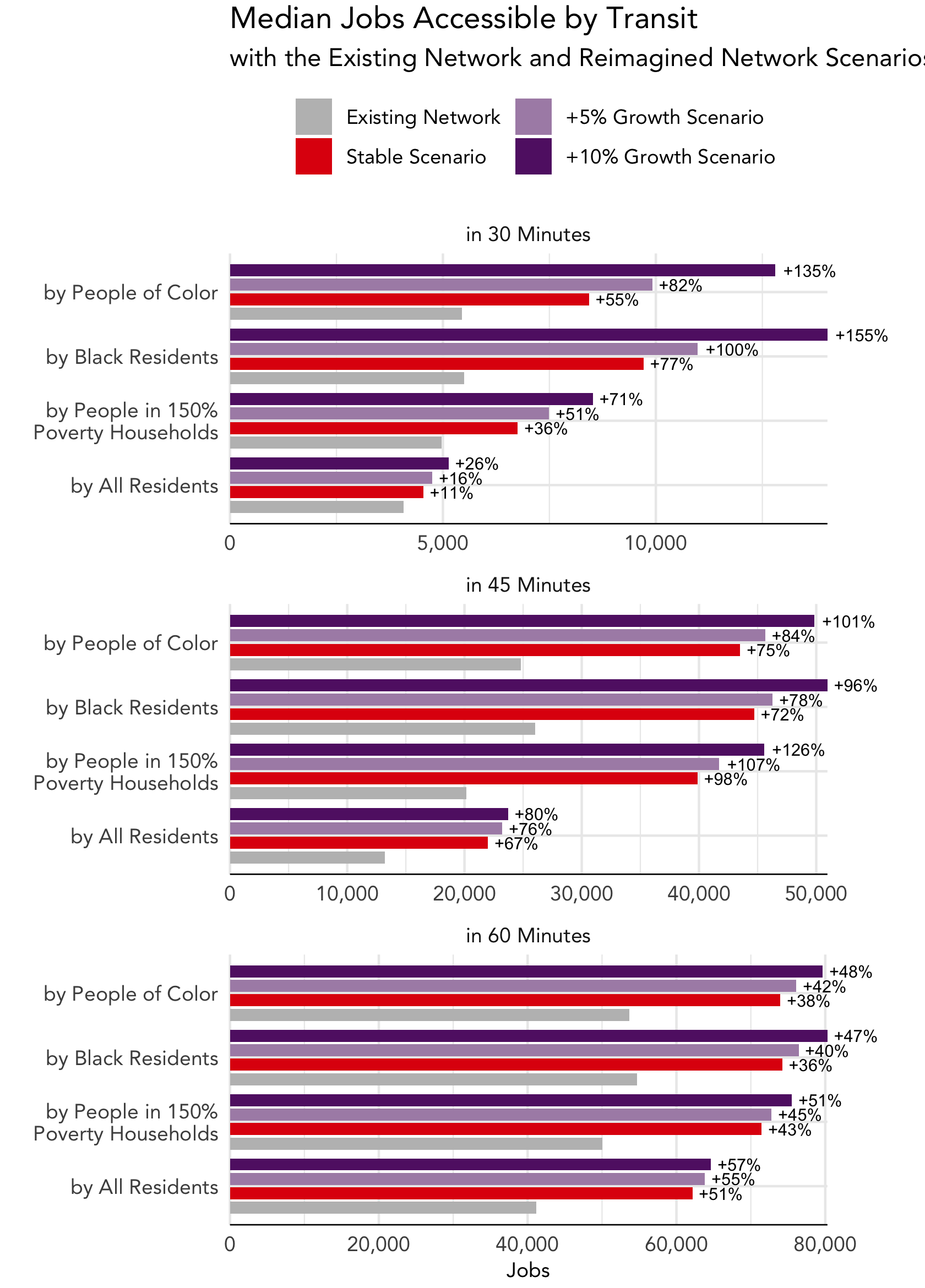
This chart compares the number of jobs reachable with the Existing Network and the Reimagined Network Stable, +5% and +10% Growth Scenarios. The grey bar shows the median number of jobs reachable with the Existing Network, while the red bar shows the number of jobs reachable with the Stable Scenario. The purple bars show access with the Growth Scenarios.
With the Existing Network, the median number of jobs reachable by Summit County residents using transit in 45 minutes is about 13,000. That means 50% people can reach fewer than 13,000 jobs, while 50% of people can reach more jobs.
The Reimagined Network would increase the median number of jobs reachable in 45 minutes by 67%.
The Reimagined Network would also substantially increase the number of jobs reachable with transit by people of color and low income population:
The median number of jobs reachable in 45 minutes by people living in households with income up to 150% of the federal poverty level (currently household income of $26,500 for a family of four in 2022) would nearly double, increasing by 98%.
The median number of jobs reachable in 45 minutes by people of color would increase by 74%.
Job access increases by even more with the +5% and +10% growth scenarios, because these networks include additional frequent services.
Access improves in most places
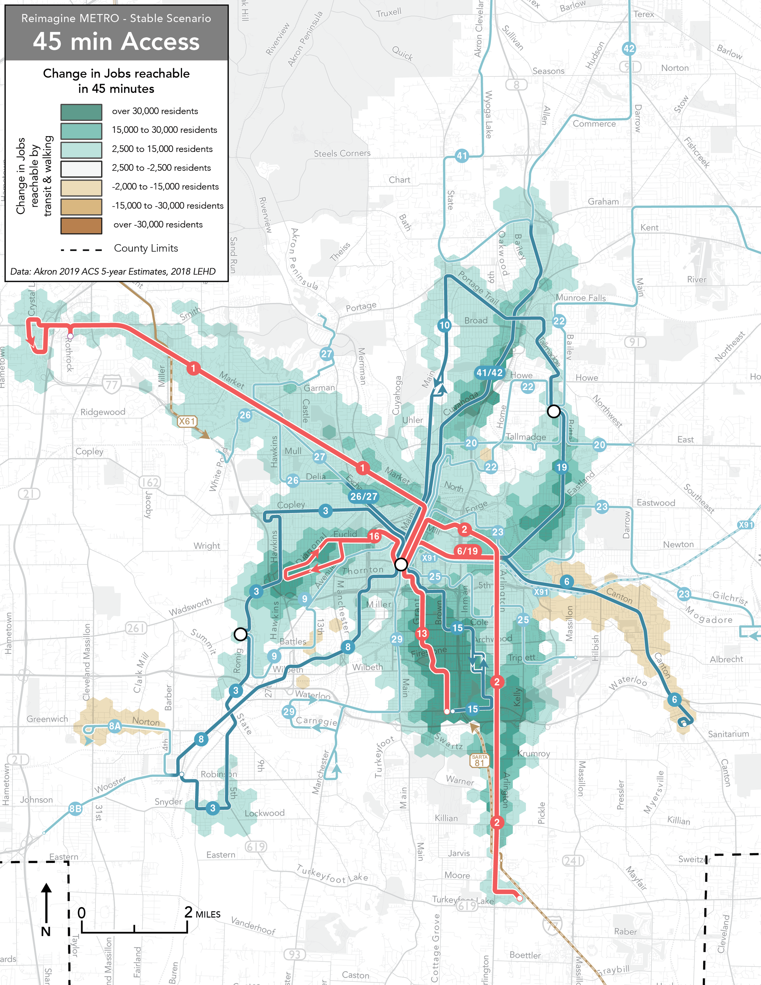
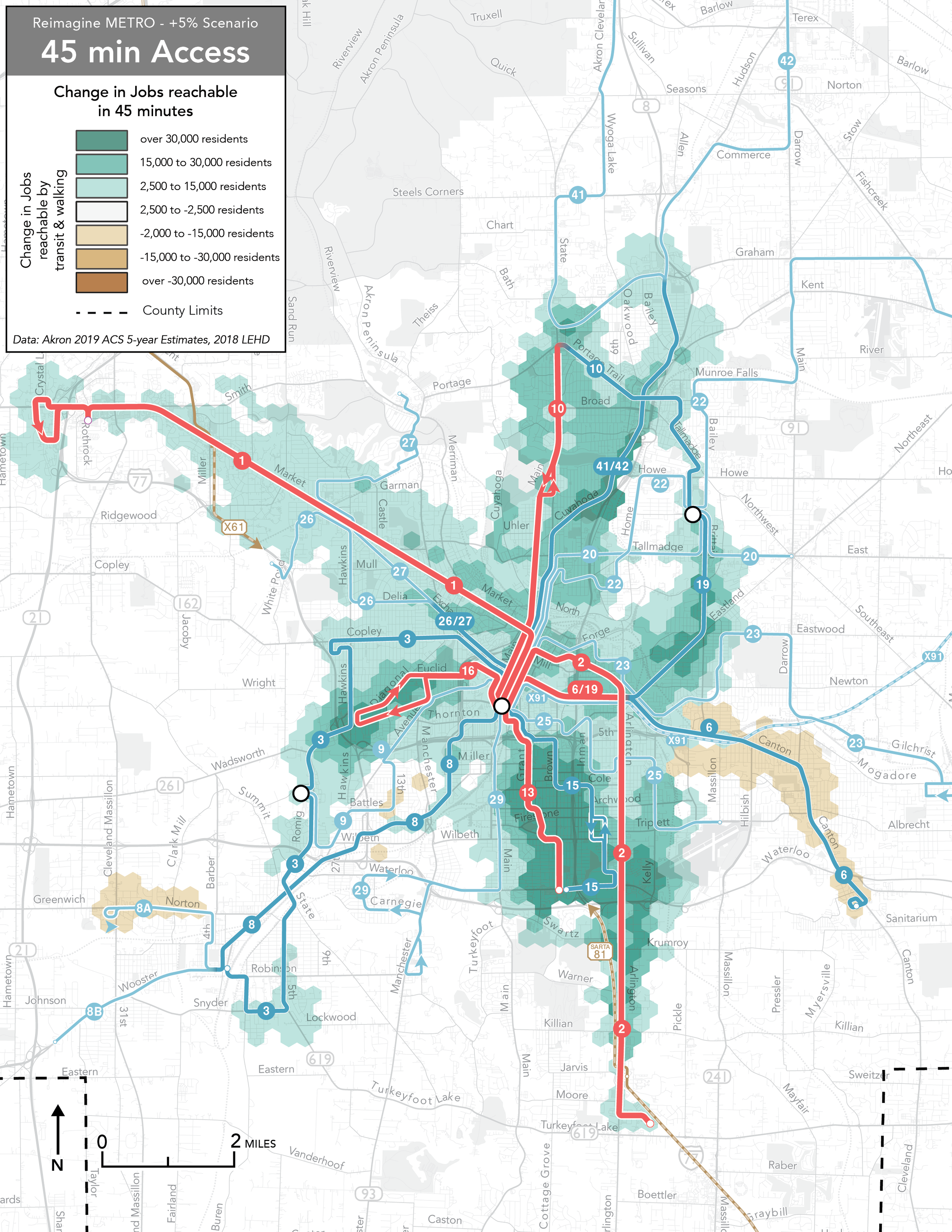
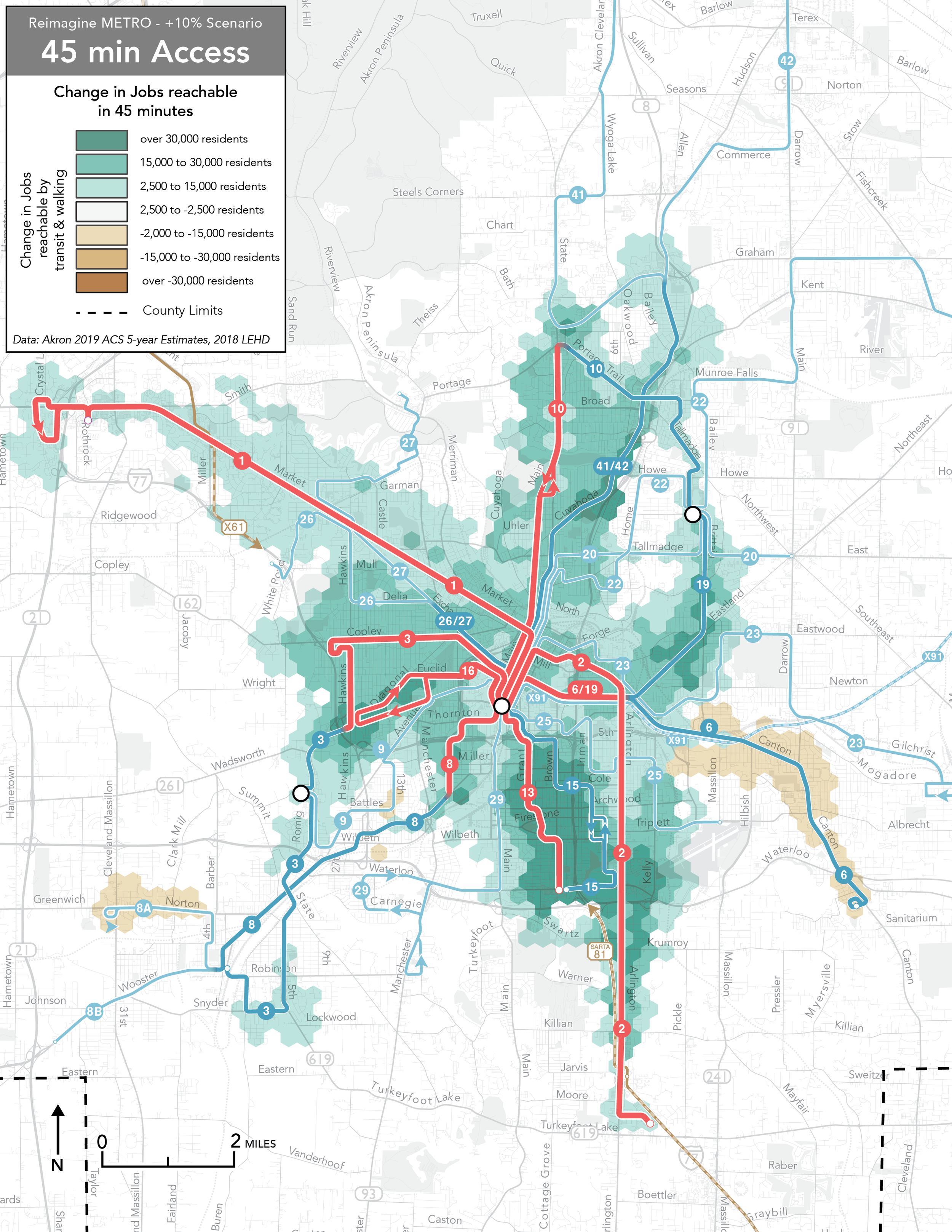
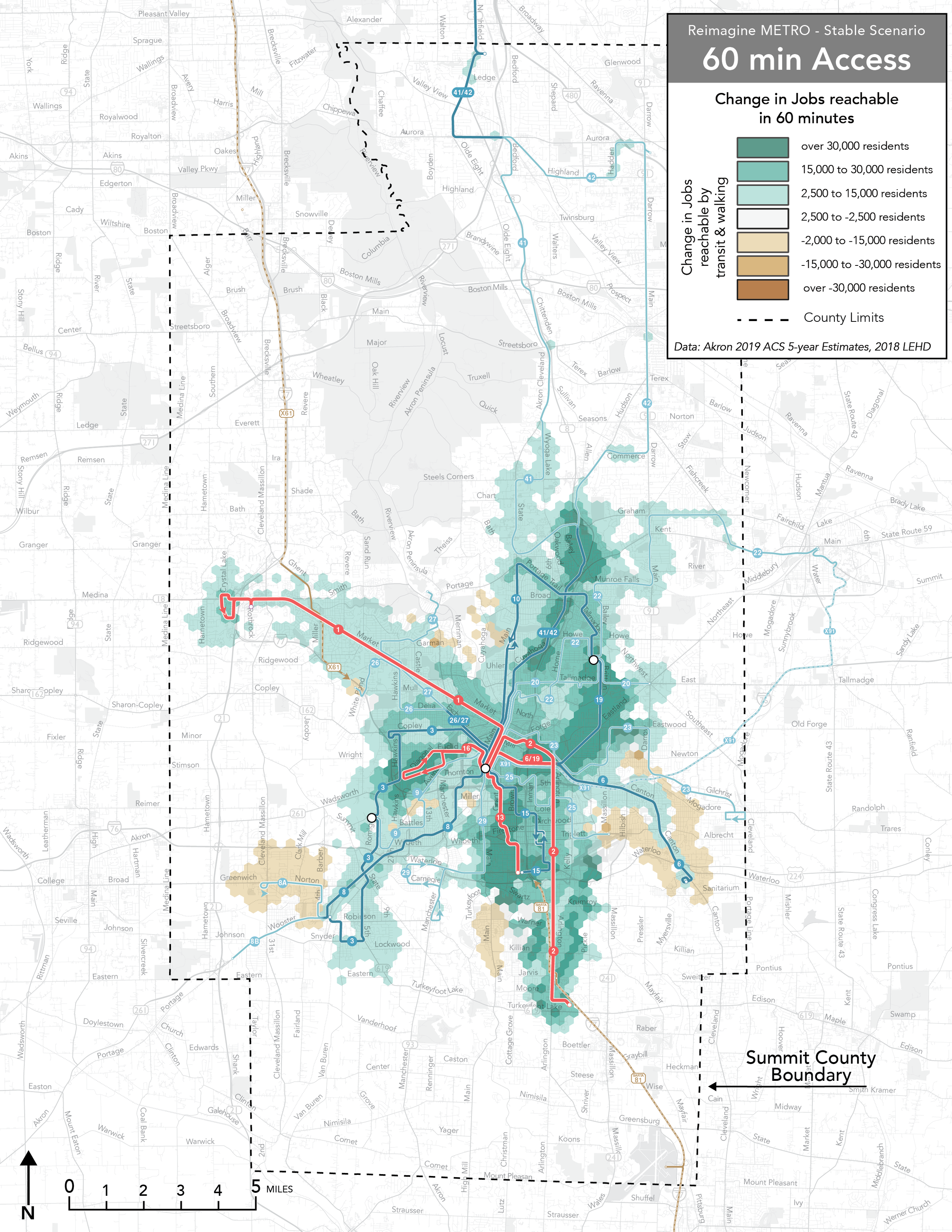
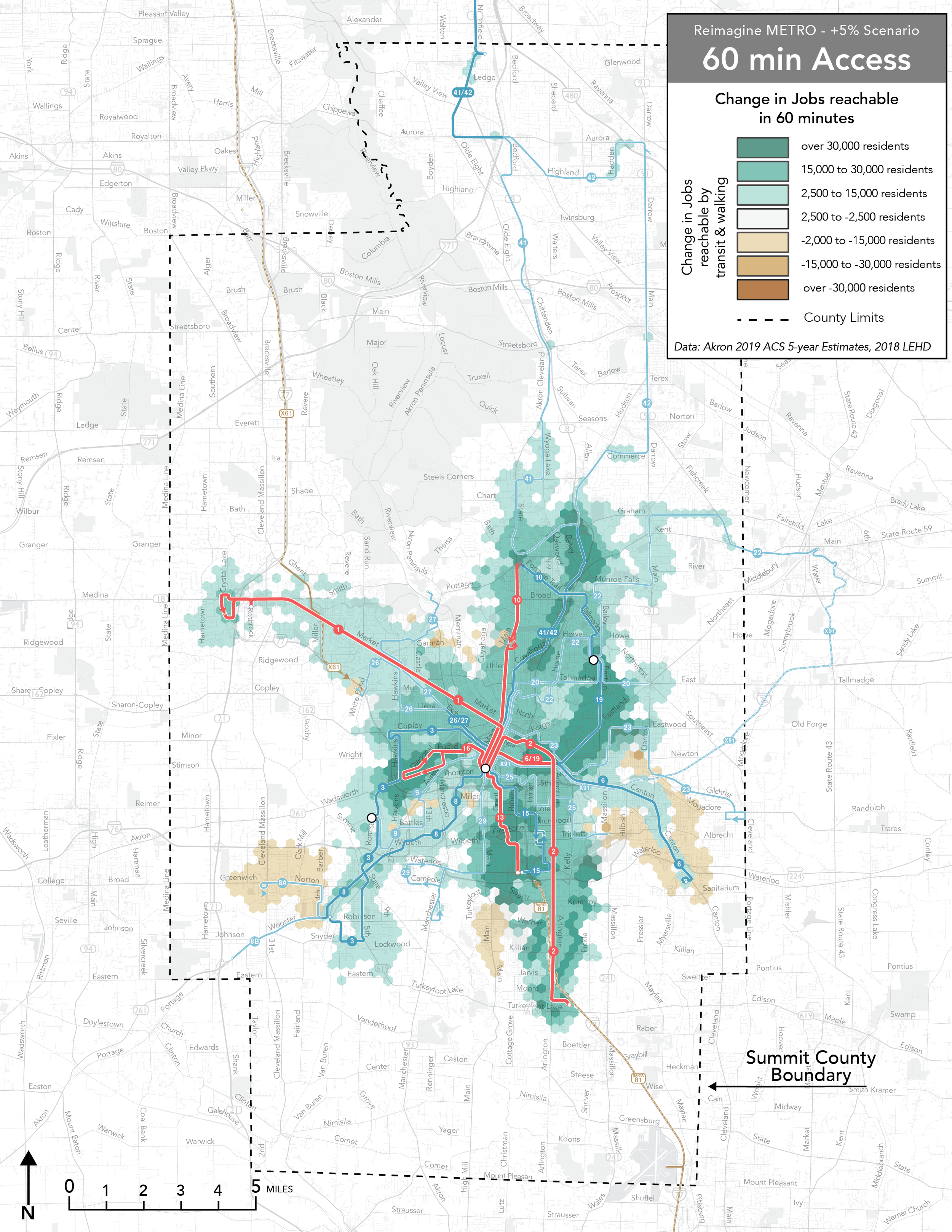
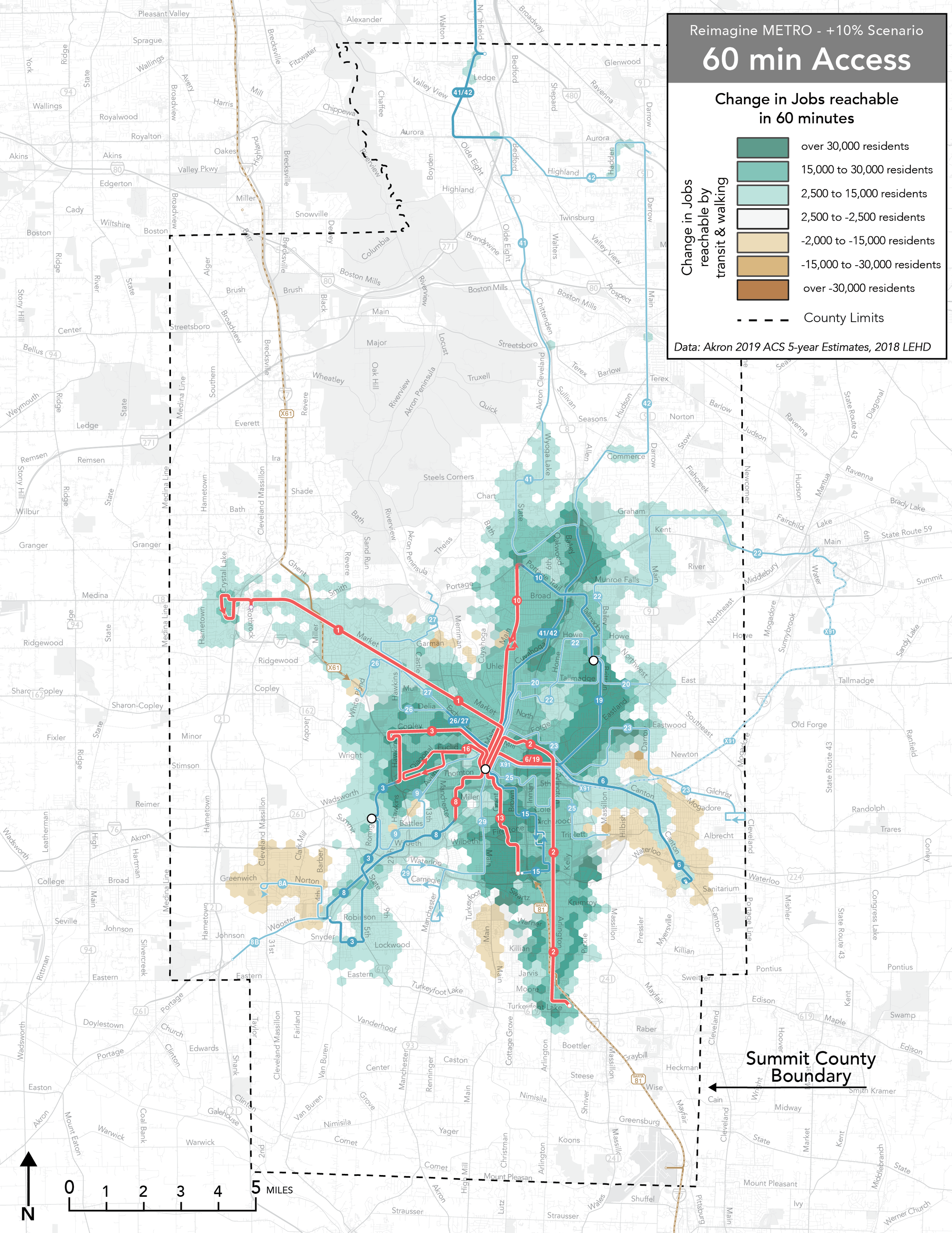
The map below shows the change in the number of jobs reachable in 45 minutes with the Reimagined Network, compared to the Existing Network. Darker green areas are places where more jobs would be reachable compared to today. Brown areas are where fewer jobs would be reachable.
WHERE DOES ACCESS INCREASE?
Some of the greatest gains in job access are near the Reimagined Network's new 15-minute frequent routes, including Routes 1 and 2, which are upgraded from 20-minute to 15-minute service. Access improvements are especially great in South Akron where the new 15-minute Route 13 and 30-minute Route 15 replace existing hourly routes.
Other places where access improves include:
Route 19 in Goodyear Heights would continue north of the Independence Transit Center through Cuyahoga Falls as Line 10. This route operates every 30 minutes, compared to existing service in this area which comes every hour.
Route 10 serves Euclid Ave every 15 minutes. The Reimagined Network upgrades a portion of the existing Route 14 from 30-minute service to 15-minute service.
The 60-minute map shows an increase in job access in northern Summit County along the new Routes 41 and 42. These routes would operate hourly; however, because this area is far from other job centers (like downtown Akron), the benefits are less apparent with only 45 minutes of travel time.
WHERE DOES ACCESS DECLINE?
Access declines in a few areas, mainly in places that would be served by less frequent routes or where service discontinued.
Around Route 6, which serves the East Market Street and Canton Road corridors. In the Existing Network, this route approaches Downtown Akron via East Market; in the Draft Reimagined Network, it comes into Downtown via East Exchange. This routing puts Route 6 further from the major employment center of Summa Health Hospital location on East Market.
Along Manchester Road, where the existing Route 18 is discontinued.
Along Norton Road in Barberton (served by the 8A branch of Route 8). The 8A branch would operate less frequently than the Existing Network’s Route 8 on this segment.
On the 60-minute map, some loss of access is also visible along Main Street in Portage Lakes, and near the Merriman Valley area currently served by Routes 11 and 28. In the Reimagined Network, Merriman Valley would be served by Route 27 and service to Portage Lakes would be discontinued.
Access improves even more with the Growth Scenarios
In the +5% Growth Scenario, the major all-day change to the network is the new addition of frequent service on Route 10 along Main from Downtown Akron through North Hill, continuing to Portage Trail in Cuyahoga Falls. On this segment, buses would run every 15 minutes, while every other bus would continue east through Cuyahoga Falls to Independence Transit Center. On the access change maps for the +5% Growth Scenario, most of the area around Route 10 now shows up as darker green shades representing more jobs reachable. In the Stable Scenario, this corridor gained access to a smaller number of jobs, because travel times to Downtown Akron didn't change compared to the Existing Network.
The +10% Growth Scenario adds frequent services on Copley and Hawkins (Route 3), and Thornton and Lake Shore (Route 8).
Upgrading Route 3 to 15-minute service increases the number of jobs reachable at 12:00 p.m. on a weekday throughout West Akron. In the Stable Scenario, only Route 16 would run every 15 minutes in West Akron; with the +10% Growth Scenario, many more people would be near a 15-minute service heading Downtown.
The new 15-minute service on Route 8 also expands the green area where job access would improve. However, Route 8 is short, and the neighborhoods it serves are cut off from other areas by Summit Lake, a railroad corridor and freeways, so the this improvement impacts a smaller area than the other frequent routes.
See how your transit access would change
You can use the webmap in the window below to compare where you could travel with the Existing Network and Reimagined Network Stable and Growth Scenarios from anywhere in Summit County. First, click “Transit Reach”, click any point on the map, and then select a travel time (45 or 60 minutes) to see how far you could travel with either the Existing Network or Draft Reimagined Network.
You can also select “Access Change” to view an interactive version of the maps shown above.
If you would like to view the webmap in a new tab or window, click here.
Now we need to hear from you!
You can share your thoughts on the Reimagined Network and Growth Scenarios by taking our survey using the link at the top of the page, or clicking the link below: